#64 Fort Pulanski, GA

Key West Trip
March 18-25, 2007
Saturday
Day 7
285 miles

The next morning while getting some coffee and a bagel, I met a little girl from Monroe, NC. Her name is Montana and she was on her way to Disney World with her family and Flat Stanley. I chatted with her a bit. I think she was surprised I knew all about the Flat Stanley saga. She was shy about it, but her Dad helped her up on Fleeter for a photo-op...for her Flat Stanley story and the Fleeter Log.
We left the Comfort Inn in Brunswick, GA heading to Savannah.

Our next stop 85 miles away -- Fort Pulaski on the east side of Savannah.


Driving through Savannah toward Tybee Island.

Entering Fort Pulaski. Yes, they were firing the cannon...and it was LOUD!

Crossing over one of the Savannah River estuaries on Fort Pulaski National Monument property.

Top of the perimeter wall looking down into the compound of Fort Pulaski.

Looking out to Tybee Island. See the lighthouse?

From this direction the Union Army attacked the Confederates in Fort Pulaski. This is the side that received the most damage during the attack.More of the damage along the same side.A close up of mortar still in the wall.
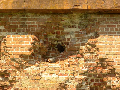
A view of the moat surrounding the fort from inside the fort. That's the visitor center in the background.
Visitors coming up to the gang plank entry to enter into the fort.


Story of the "waving girl."

Ship going back out to sea along the channel leading to downtown Savannah.

I took it's picture, but I DID NOT run out to wave at it. Riding back to Savannah. You always have to be on watch for the critters on the road.

Once we made it back into South Carolina, we decided to get off the freeway and enjoy some smaller US highways. This is where you see more of the interesting stuff.


We made it into Florence, SC for the night. We stopped in Santee to check room availability for the night. I found a coupon room still available at the Sleep Inn. An hour later (7:30pm) we were checking in and eating fresh cookies at the front desk!

Night in Florence, SC

Sunday

Day 8

356 miles

The next morning we took a relaxed start at 9:30am heading home.

We can tell we're working our way north -- not just by the map, but by the weather. We've left the high 70 degree weather behind for 60-70 degree weather. The sun is shining so it's still great riding weather. But at a gas stop in North Carolina, we decided it was time to trade the summer mesh jackets for warmer textile. Brrr, it's getting chilly again!

We decided it was time for something to eat when we made a fuel stop in Petersburg, VA.

Nearby, we found a great little Italian place nearby -- Rosa's.

We were delayed by an accident that initiated stop'n'go traffic north of Richmond, but still made it home by 5:30pm. Even had time to start a fire. We gathered around and reminisced about our trip to Key West.

Total trip: 2,477 miles

Total trip time: 8 days, 7 nights

States fleetered in this trip: 5


#63 Braking for Florida Stamps

Key West Trip
March 18-25, 2007

Friday
Day 6
242 miles

We leave the Best Western Space Shuttle Inn, top off the gas tanks across the street, and start our day's trek. Our day starts in Titusville...right where we ended last night.

Crossing the Indian River from Titusville to Merritt Island.

This was a real nice visitor center where 4 stamps were located.
One NPS and three "blue goose" NWR stamps.
Entering Canaveral National Seashore.

See that Ranger booth with the flag in the background? There's a stamp in that booth.
Be prepared. When you request the stamp, the ranger will stamp your book for you rather than handing over the stamp.
Can you see the launch site at the Kennedy Space Center in the background?Launch site 39 are where the space shuttles are launched.Up and over the dunes and there's the Atlantic Ocean. The road follows along this canal for quite a ways. If you keep an eye out, you just might see an alligator.Sure enough. We saw one. Leaving Canaveral National Seashore, we stopped at the Manatee Observation Platform to check if any manatee were making a showing. There were a couple there, but down from the platform far enough that it was hard to make out enough detail for photos.

Less than 100 miles up the shoreline, we stopped at Fort Matanzas and got another stamp.After leaving Fort Matanzas, we rode about 12 miles to the Oasis, a cool local place to eat for a late lunch. They even had a special place for "motorcycle only" parking right up front.
As we left the Oasis, I heard it again... I think it's my brakes. Doesn't sound just right. I heard it earlier at Fort Matanzas. But thought maybe it was dust and dirt on the brake pads. We had pulled into a dirt parking lot shortly before Fort Matanzas to take another look at the Atlantic Ocean. But now the sound seems worse instead of better. Hmm... I pull down a side street and motion us over to a parking lot. When I tell Sylvia to listen as I circle around and brake. Before I could even get to her, she validated my thought, "not a good sound" to be hearing when over 700 miles from home...and on a Friday afternoon.
First things first. I borrowed a phone book from the office of the motel's parking lot, which we had also just used. The nearest Yamaha dealer was about 5 miles back south on US1. We pulled into U.S. One Powersports' parking lot a few minutes later. They took Fleeter right in...sure enough - brake pads were shot. They replaced them and got us back on the road just after 6pm. Sylvia even took advantage of the down time and got her Honda VTX an oil change.
Now running even more behind our schedule, we missed Castillo de San Marcos, Fort Caroline and Fort Frederica. Those would just have to wait for another trip south.
Instead, we got on IH95 and booked it 100 miles north to Brunswick, GA for the night at the Comfort Inn. This would put us in a good position for visiting Fort Pulaski the next morning.
Night in Brunswick, GA.

#62 Rain on the Florida Turnpike

Key West Trip
March 18-25, 2007
Thursday
Day 5
282 miles
We awoke to heavy thunderstorms. Checked the weather channel, rolled over and went back to sleep. The large cell coming in from the Atlantic might blow past in a couple hours. Mid-morning we packed up and waited for a clear spot to show in the sky, then we rode toward it.

It was a good plan, but, alas, not to be. About a 1/2 mile down the road, we got poured on. And all the water already on the roads caused for solid sprays every time we met vehicles...and we met a lot of large trucks on our way to Convoy Point!

The rain slowed to a drizzle by the time we pulled into the Biscayne NP entrance.

Yes, the GPS (Garmin 2730) is waterproof! It has made it through several downpours between Virginia, Texas, New Jersey, Florida, etc. so I am not concerned about it's rain-worthiness.

The Visitor Center was a pretty interesting place at a cool location, but we didn't take a lot of time exploring. We were more concerned in heading back west before the next storm brewing over the waters of the Atlantic came ashore.

Nice to know the reflective properties of my gear is doing its job! Check out the strip of tape I put on my helmet. Look for the stealth tape on the luggage in other photos.

Nice mosaic with coordinates documented.

Since we still had hopes of outsmarting the rain (ha, ha), we only "stuck our big toes" in Everglade NP.

When we pulled into this parking lot it was still drizzling and the area we parked in was at the edge of a huge puddle. None of the cars were parking there so we felt safe parking askew at the edge and taking up two unmarked slots. When we came out about 20 minutes later the puddle had drained away and the bikes looked rather awkwardly parked. Good thing the parking lot wasn't even 1/4 full. I guess rain makes for a slow tourist day in the Everglades.

During a light spot in the rain, we leave the visitor center and head north.

It looked like the rain was all south of Miami. We thought if we could just get on the north side of Miami, we'd have a safer and more enjoyable ride. That theory held all of 20 or so minutes. We jumped up on the Florida Turnpike in Florida City to make time getting north. We were already behind schedule since we slept in during the morning thunderstorms. The thunderstorms were very unpredictable - unless maybe you were a meteorologist or a local. It seemed they were developing just offshore in the Atlantic and moving inland at their whim.

What this meant to us...

Heavy, heavy rain then clear weather, then heavy rain, then a bit of sun, then rain, then ... oh you get the idea.

What this means to you...

No pictures. Though I'm usually not shy about taking pictures while moving down the road on Fleeter (many of the ones you see, I took that way), I didn't feel it was very smart to take the camera out of my tank bag in the rain, on the turnpike (fast traveling road), with wet bulky gloves...

What I saw, but didn't get pictures of...

1. Miami-Homestead Speedway on the way to Biscayne NP. I don't follow such things, but it appeared they were gearing up for something big.

2. A panther crossing sign as we left Everglades NP. I looked, but didn't see any....panthers.

3. Migrant workers picking zucchini. This was interesting because as we rode by on the way to the Everglades I decided from the smell that it was squash in the fields. But I didn't know for sure. Then on the way back from the Everglades, I saw the big baskets full of zucchini squash. The nose knows!

4. KEY LIME MILKSHAKES?! I was a bit disappointed that it wasn't warm enough to encourage a stop at ROBERT IS HERE produce stand. I was intrigued by the advertisement for KEY LIME MILKSHAKES. Next time, I'm stopping to try one! http://www.insiderpages.com/b/3712492976

A borrowed photo from the Internet......
5. And last but not least, the HARD ROCK CASINO. Anyone who has watched ANY TV in the last couple of months would know it if you saw it. I had no idea where it was and wasn't even thinking (or interested) about it. But riding along the Turnpike, there it was ... big as ever. Oh well, probably not worth mentioning, but I did. If you're still clueless (or don't watch TV or listen to the news on the radio... This is where Anna Nicole Smith died.

W arrived at the Best Western in Titusville before 8pm. We got checked in, unpacked, and ate at the Durango Steakhouse onsite. Life is good.

Not a bad day at all for all the rain.

Learned today:

1. If I lace up my Wolverine boots REAL TIGHT, and don't wiggle them around a lot, they are mostly waterproof. This is a good thing!

2. The Florida Turnpike is worth the $10 or so to avoid Miami traffic. I recommend taking it when south of Pompano Beach though we were on it from Florida City all the way to Fort Pierce. (Unless you want to go to Miami?!)

Night in Titusville, FL

#61 Leaving Key West

Key West Trip
March 18-25, 2007
Wednesday
Day 4
124 miles

It was a quick stay in Key West. If we stayed any longer, we'd run the risk of becoming affected with the "Don't Wanna Leave" Syndrome.

Before leaving, we made a run by the beach...

... and a drive by the Key West Lighthouse.

Interesting notation: Even chain businesses in Key West are unique.

When crossing "Big Pine Key" watch out for the Key Deer.

Key Deer is an endangered species...so don't hit one. Drive slow and look out!

This is the National Key Deer Refuge. http://www.fws.gov/nationalkeydeer/

The Key Deer (Odocoileus virginianus clavium) is an endangered deer that lives only in the Florida Keys.

It is a subspecies of the White-tailed Deer (O. virginianus), but smaller. The adult male only reaches 30 inches tall at the shoulders in adulthood. Other than that they look like White-tailed Deer. The deer easily swim between the islands.

Key Largo: the First and Last stop in the Keys...

While in Key Largo on our way south, we ate at Sundowners.

But we talked to a group of guys doing a 4 Corner Tour that Senior Frijoles is good too. Time to head back to the mainland.

US1 crosses Barnes Sound on the way to the mainland.

As you can see, looks like some wet weather ahead.

We hit some light rain showers on our way into Florida City.

Hoping to avoid any heavy rain, we shut it down for the night.

Sure enough we had heavy rains during the night.

Leaving the Conch Republic, heading back north of Latitude 24.